Title: Photographs of colonial Indonesia, New Guinea and Pacific Islands 1900-1905
Year: 1900/1905
Location: Jakarta, Indonesia
Source: https://ark.colorado.edu/ark:/47540/hg305713c7cs
Canals and Floods
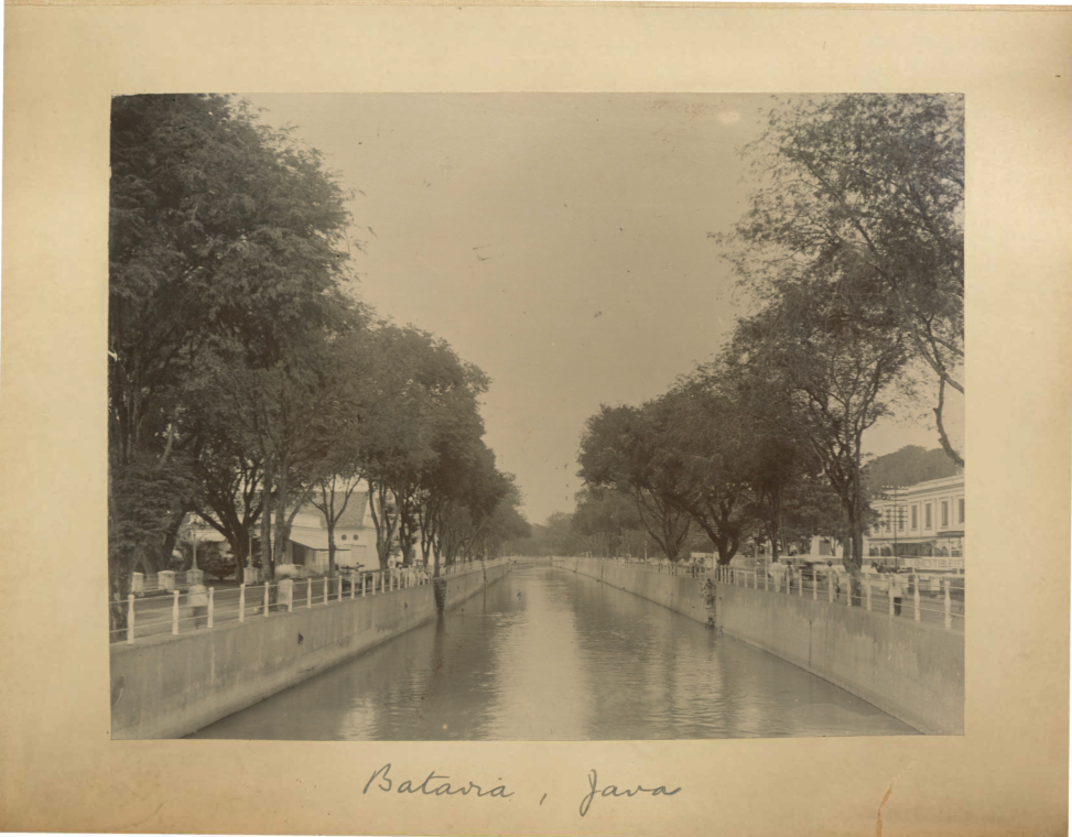
The image is a photograph of the Molenvliet canal constructed by the Dutch East Indies government which was the central canal that connected the entire canal system spread throughout Jakarta. I chose this image as it offers insight into the history of one of Southeast Asia’s most prominent colonial cities and the capital of the Dutch colonial empire and the effects of its iconic canals in modern times.
Before Batavia was founded, the location was the site of a Dutch fort which was established on top of the razed city of Jayakarta after a conflict with local powers. In 1619, The fort was to be formally expanded into a proper castle known as Batavia Castle to serve as the staging ground for increased activity in Southeast Asia. The first canals were constructed as part of this expansion primarily for the transportation of goods and as drainage for the floods that regularly occurred due to the yearly monsoon seasons but also functioned as moats for defensive purposes. The canal seen in the image is the Molenvliet canal which was part of a second expansion called the Southward Expansion constructed some time in the 1840s, more than two centuries after the initial expansion of Batavia Castle. Batavia and its canals are interesting as the whole city was planned and built in similar style of Dutch cities in Europe. The canals distinguished Batavia from other colonial cities as it was uniquely Dutch to use their knowledge and technology in marine construction to build Batavia in their image. However, over time the canals became polluted and the Ciliwung river contaminated rendering both unsafe to drink. The polluted canals also became hotbeds for mosquitoes causing frequent malaria outbreaks over the centuries. The original problem of flooding was also never really solved even after multiple expansions of the canal system by the Dutch. The sedimentary nature of the rivers meant that constant maintenance in the form of dredging was required. Furthermore, the problem was compounded in 1699 when an earthquake caused an increase in sedimentation levels.
Today, flooding is still a major issue that plagues Jakarta. In 2007, a major flood occurred which was considered the worst in the last three centuries. Up to 80 people were killed and an estimated $400 million of property damage. The 2008 flooding showed the problems that Jakarta was facing in the modern world. It is believed that the flood was a combined result of heavy rain, deforestation in the south of the city, and the lack of maintenance of the canals which were clogged with trash. Most of those killed were the poor as poor communities usually built makeshift houses and shacks on the sides of the rivers and canals as it provided them free water for consumption and for washing, although the water was extremely unsafe as the rivers and canals are commonly used for illegal trash dumping. The 2008 flood also saw a rise in dengue fever and diarrhea as the polluted waters made it into most homes.
It is believed that if the canals and rivers of Jakarta were properly maintained then the effects of the floods would have been mitigated. The issue of flooding dominates the local city politics of Jakarta but the prevalence of corruption within the Indonesian government had caused inaction amongst officials to even attempt to address the situation. So far, the local government still has not yet announced any plans to mitigate future floods nor future canal expansions although an initiative to clean the waterways was launched in 2016 by the Governor of Jakarta at the time, Basuki Tjahaja Purnama. The flooding combined with the threat of Jakarta sinking from groundwater subsidence has caused the national government to change its capital city from Jakarta and to build an entirely new city on the island of Kalimantan (Borneo) showing that even the national government has a pessimistic view about the future of the city.
I think that the image is an interesting look of the past. I did not know much about the history of the city I grew up in until now and it is astonishing that the canal in the photographs is Jakarta as it looks like what you might see in Amsterdam. Nowadays, however, everyone who lives in Jakarta avoids the waterways due to the smell, the trash, and the possibility of mosquitoes. It makes me sad that I never really saw Jakarta as how it looked in the image but at least through this activity, I was able to discover the past and learn something new about the city that I took for granted.
References
“Jakarta.go.id • Detail” Encyclopedia, web.archive.org/web/20131203002232/http://www.jakarta.go.id/eng/encyclopedia/detail/207. Accessed 30 April 2023.
“Ekspedisi Ciliwung: laporan jurnalistik Kompas : mata air, air mata” Google Buku, books.google.co.id/books?id=QMhiTccSICUC&pg=PA91&dq=Molenvliet&hl=id&sa=X&ei=rk2KUZDGBJDLrQfgxoHYCQ&redir_esc=y. Accessed 30 April 2023.
“Jan Pieterszoon Coen (1587-1629) – Stichter van Batavia” Historiek, 21 Aug. 2015, historiek.net/jan-pieterszoon-coen-1587-1629/5545/. Accessed 30 April 2023.
“Death Toll from Jakarta Flood Reaches 50” web.archive.org/web/20070212191902/http://www.cbn.com/CBNnews/100348.aspx. Accessed 30 April 2023.
“Ahok dreams of city rivers people can swim in” The Jakarta Post, 19 May 2016, www.thejakartapost.com/news/2016/05/19/ahok-dreams-of-city-rivers-people-can-swim-in.html. Accessed 30 April 2023.